


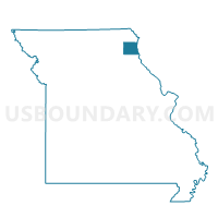
Canton Voting District, Lewis County, Missouri
About
Outline

Summary
| Unique Area Identifier | 608955 |
| Name | Canton Voting District |
| County | Lewis County |
| State | Missouri |
| Area (square miles) | 57.17 |
| Land Area (square miles) | 55.14 |
| Water Area (square miles) | 2.03 |
| % of Land Area | 96.45 |
| % of Water Area | 3.55 |
| Latitude of the Internal Point | 40.18933810 |
| Longtitude of the Internal Point | -91.56762350 |
Maps

Graphs
Select a template below for downloading or customizing gragh for Canton Voting District, Lewis County, Missouri


Neighbors
Neighoring Voting District (by Name) Neighboring Voting District on the Map
- Clay/Des Moines No. 1/Des Moines No. 2 Voting District, Clark County, MO
- Jackson No. 2 Voting District, Clark County, MO
- LIMA 1 Voting District, Adams County, IL
- Maywood Voting District, Lewis County, MO
- Monticello & Benjamin Voting District, Lewis County, MO
- ROCKY RUN Voting District, Hancock County, IL
- URSA 1 Voting District, Adams County, IL
- Williamstown & Derrahs Voting District, Lewis County, MO
Top 10 Neighboring County Subdivision (by Population) Neighboring County Subdivision on the Map
- Canton township, Lewis County, MO (3,501)
- Union township, Lewis County, MO (1,872)
- Ursa township, Adams County, IL (1,073)
- Lima township, Adams County, IL (534)
- Dickerson township, Lewis County, MO (452)
- Jackson township, Clark County, MO (434)
- Lyon township, Lewis County, MO (431)
- Clay township, Clark County, MO (378)
- Rocky Run township, Hancock County, IL (158)
Top 10 Neighboring Place (by Population) Neighboring Place on the Map
Top 10 Neighboring Unified School District (by Population) Neighboring Unified School District on the Map
- Lewis County C-1 School District, MO (6,554)
- Clark County R-I School District, MO (6,053)
- Community Unit School District 4, IL (4,314)
- Canton School District, MO (4,008)
- Warsaw Community Unit School District 316, IL (2,653)
Top 10 Neighboring State Legislative District Lower Chamber (by Population) Neighboring State Legislative District Lower Chamber on the Map
- State House District 93, IL (103,943)
- State House District 94, IL (100,005)
- State House District 1, MO (33,818)
Top 10 Neighboring State Legislative District Upper Chamber (by Population) Neighboring State Legislative District Upper Chamber on the Map
Top 10 Neighboring 111th Congressional District (by Population) Neighboring 111th Congressional District on the Map
Top 10 Neighboring Census Tract (by Population) Neighboring Census Tract on the Map
- Census Tract 101, Adams County, IL (4,451)
- Census Tract 9701, Lewis County, MO (3,410)
- Census Tract 9703, Lewis County, MO (2,659)
- Census Tract 9542, Hancock County, IL (2,460)
- Census Tract 9702, Lewis County, MO (2,306)
- Census Tract 9502, Clark County, MO (2,169)
- Census Tract 9704, Lewis County, MO (1,836)